|
Welcome to the world. We will journey together across the world learning all the basics and more about what our land offers. We'll look into flags, location, history and more as we broaden our horizon and make future references easier to make with more knowledge. So buckle in as we journey across the world!! ContinentsThe world is divided into 7 different areas of land. These areas are cover a huge amount of our planet and these are called "CONTINENTS". There are 7 of these Continents and they are North America South America Europe Asia Africa Oceania Antarctica These areas are generally quite easy to recognise (however there some disputes were some start and end so we'll look at them a bit later on) AFRICAThe First Continent we'll introduce is AFRICA. Africa is the world's second-largest and second-most-populous continent, after Asia. At about 30.3 million km² including adjacent islands. With 1.3 billion people (as of 2018,) it accounts for about 16% of the world's human population. It's home to 54 countries ranging in sizes and shapes. Its biggest is Algeria in terms of land size. However, in population, it only ranks 9th. The largest population is NIGERIA. 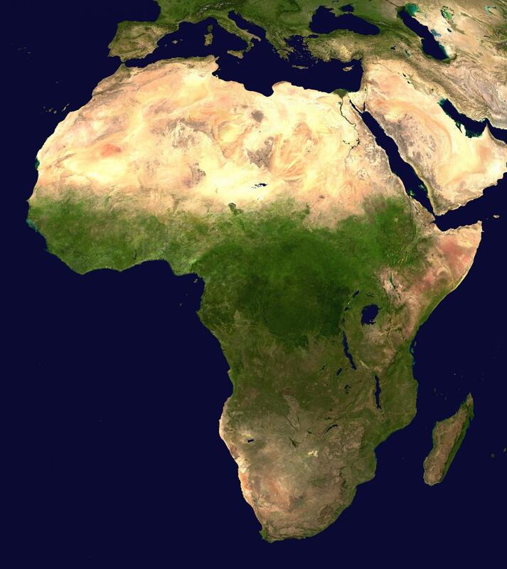 Africa is visibly a diverse piece of land. In the Northern part of Africa, you are able to see a desert going across from west to east. This is the Sahara desert and it is the largest single desert in the World spanning a whopping 9,200,000 square kilometres (3552139.859 square miles). This is similar to the size of the USA and CHINA. Towards the middle of Africa, you can see a big patch of Green. This is the Congo rainforest. Its the largest rainforest in Africa and the 2nd largest in the World. It follows the Congo river which famously splits 2 countries with Similar names The Republic of the Congo and The Democratic Republic of the Congo (also known as D.R. Congo). EUROPEThe next continent we'll look at is EUROPE. Europe is a continent located entirely in the Northern Hemisphere and mostly in the Eastern Hemisphere. It comprises the westernmost part of Eurasia and is bordered by the Arctic Ocean to the north, the Atlantic Ocean to the west, the Mediterranean Sea to the south, and Asia to the east. Europe covers a land area of 10.18 million km² (3930519.974 square miles). Europe had a total population of about 741 million (about 11% of the world population) as of 2018. It is home to 46 countries with Russia being the Largest in both land size and population size. 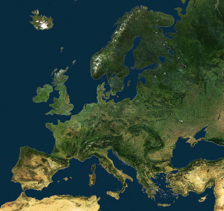 Unlike Africa, Europe is pretty consistent throughout in terms of its land. All through Europe, there are areas of flat terrain and mountainous terrain. However in Spain, you'll see some desert. It's not on the scale of the Sahara desert in North Africa it still counts a desert. The Tabernas Desert covers the province of Almeria in the country. NORTH AMERICANorth America covers an area of about 24,709,000 square kilometres (9,540,000 square miles) making North America the third-largest continent by area, following Asia and Africa. It's home to 23 countries which in 2013, the population was estimated at nearly 579 million people.  When you look at North America, you may get overwhelmed by its sheer diversity. However, we'll break it down quite simply for this post. However, there is also a whole post looking at North America by each country (this will be done for all continents) Let's start with the islands to the east of the continent. These islands are part of a group called "The Caribbean". These islands are popular places for all you beach lovers. Many cruises go from island to island so you can enjoy what each island offers. Now to the big white island in the northeast of North America. This is known as Greenland. This is the World's largest island. Although it's geographically part of North America, it's owned by Denmark in Europe so don't start thinking Canada or the USA own it because well they don't. There's a tail to North America from Mexico down to the tip of South America. This is known as Central America. This area is mainly rain-forest all the way down until the world-famous Panama Canal
SOUTH AMERICASouth America has an area of 17,840,000 square kilometres (6,890,000 sq mi). Its population as of 2018 has been estimated at more than 423 million. South America ranks fourth in area (after Asia, Africa, and North America) and fifth in population (after Asia, Africa, Europe, and North America). Brazil is by far the most populous South American country, with more than half of the continent's population. South America is home to 12 countries 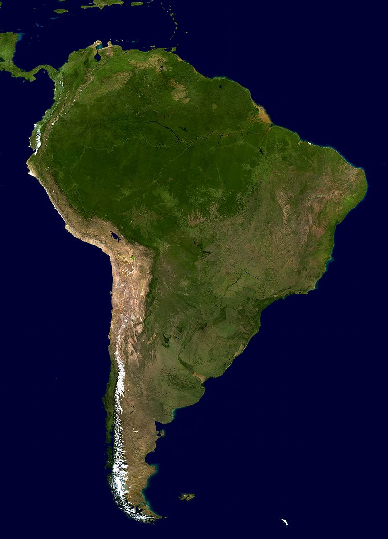 South America only really has 2 basic biomes you need to know of. The Amazon Rain forest in the North and the Andes Mountain Range in Chile (south) The Amazon rainforest, covering much of northwestern Brazil and extending into Colombia, Peru and other South American countries, is the world’s largest tropical rainforest, famed for its biodiversity. It covers a staggering 5.5 million km² (2.1 million square miles) The Andes, running along South America's western side, is among the world's longest mountain ranges. Its varied terrain encompasses glaciers, volcanoes, grassland, desert, lakes and forest. It covers an amazing 3.371 million km² (1.3 million square miles) These are the 2 main things you'll see on a South American map ASIAAsia covers an area of 44,579,000 square kilometres (17,212,000 sq mi), about 30% of Earth's total land area and Asia is notable for not only its overall large size and population but also dense and large settlements, as well as vast barely populated regions. It's 4.5 billion people (as of June 2019) constitute roughly 60% of the world's population. 48 nations call Asia there home 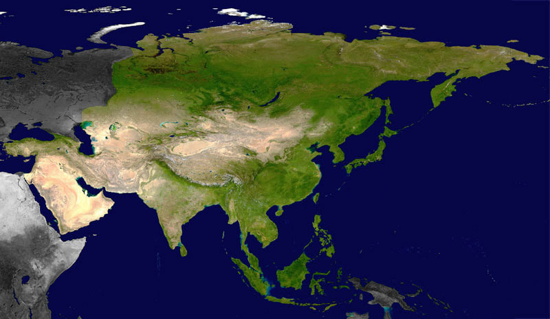 Okay, this is quite overwhelming. You may be thinking "Asia is massive. It has way too many different things. Where do I start?" Well, let's just break it all down into smaller regions. Let's start on the left. This desert region is known as "The Middle East". This region alone is very complex politically however we'll get onto that on a different day. At the top of the region, you'll find Turkey. Turkey is technically part of Asia and Europe and Istanbul is known as the Landbridge between the two continents. The main desert area of the Middle East is on what's known as the "Arabian Penisula" there are 7 countries on the peninsula. Moving slightly east, we'll call this central Asia. This is where you'll find the largest lake in the world (Caspian Sea) and many of the World's landlocked countries. One of these is the new up and coming nation of Azerbaijan. The city of Baku is found here and is becoming more popular for sporting events. Here you'll find empty vast deserts in huge nations. We move onto India. The region here is one of the most politically intense area's you could find yourself in. India and Pakistan have a lot of hatred and their very hilly border is at the forefront of this rivalry. We'll now move onto China, Japan, Korea and South East Asia. There's not much to talk about here for this blog. This area is a booming part of the world in terms of finance and technology and tourism. From all you Gap year travellers going to Thailand to those heading to Japan for their world-famous culture, this area is very popular to visit OCEANIA Oceania has a land area of 8,525,989 square kilometres (3,291,903 sq mi) and a population of over 41 million. Situated in the southeast of the Asia-Pacific region, Oceania, when compared to continental regions, is the smallest in land area and the second smallest in population. 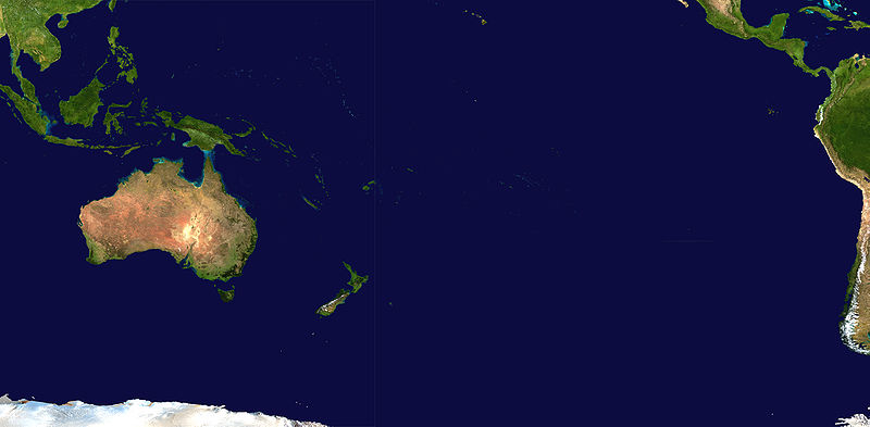 As you can see, Oceania is quite huge. However its actual size is small compared to how much of the map it takes up. The first thing you'll notice on this part of the map is Australia. This major island is the largest country in this region. Its home the outback in the middle of the country and the Daintree Rainforest towards the coast. Oceania also goes over a line called " the International Date line" which means that there's a massive time difference between some nations even if they're very close together. There are 10,000 islands in the region (excluding Australia, New Zealand and Papua New Guinea) AntarcticaAntarctica, the southernmost continent and site of the South Pole, is a virtually uninhabited, ice-covered landmass. At 14,200,000 square kilometres (5,500,000 square miles), its the 5th largest Continent 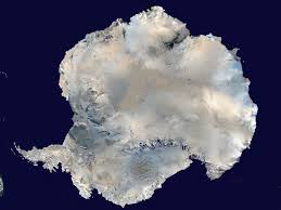 Argentina, Australia, Chile, France, New Zealand, Norway and the United Kingdom have territorial claims to parts of Antarctica. Some overlap however so i'll show all of the claims of land in Antarctica. 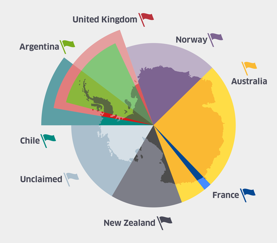 Now we've introduced our planet, I think its time you purchased a world map so you are able to easily show off your knowledge. Links to buy World Maps. Amazon GB Posters Wish Thank you so much for joining me on this introduction to the World. The next post will be all about the African Nations. We'll dive into all the information you'll ever need about each African Nation
0 Comments
|
 RSS Feed
